
Make a donation
Gear up for your next adventure:
As an Amazon Associate, this site earns from qualifying purchases at no extra cost to you.
Skopelos topographic map
Click on the map to display elevation.
Make a donation
Gear up for your next adventure:
As an Amazon Associate, this site earns from qualifying purchases at no extra cost to you.
Skopelos
The second largest settlement is Glossa village, situated on the northwestern tip of the island, just above Loutraki harbour, with an elevation ranging from 200 to 300 m (656 to 984 ft). It is 25.4 km (15.8 mi) from Skopelos town. It is a tranquil village with traditional houses, with 993 residents.
Make a donation
Gear up for your next adventure:
As an Amazon Associate, this site earns from qualifying purchases at no extra cost to you.
About this map
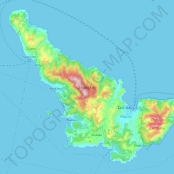
Name: Skopelos topographic map, elevation, terrain.
Average elevation: 59 m
Minimum elevation: 0 m
Maximum elevation: 660 m
Make a donation
Gear up for your next adventure:
As an Amazon Associate, this site earns from qualifying purchases at no extra cost to you.