
Town of Dryden topographic map
Interactive map
Click on the map to display elevation.
About this map
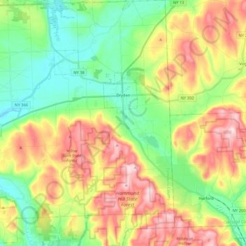
Name: Town of Dryden topographic map, elevation, terrain.
Location: Town of Dryden, Tompkins County, New York, United States (42.39623 -76.45407 42.55049 -76.25400)
Average elevation: 430 m
Minimum elevation: 302 m
Maximum elevation: 619 m
Other topographic maps
Click on a map to view its topography, its elevation and its terrain.
Ithaca
United States > New York > Tompkins County > Ithaca
Ithaca, Ithaca Town, Tompkins County, New York, 14850, United States
Average elevation: 370 m
City of Ithaca
United States > New York > Tompkins County
City of Ithaca, Tompkins County, New York, United States
Average elevation: 195 m
Dryden
United States > New York > Tompkins County > Dryden
Dryden, Dryden Town, Tompkins County, New York, 13053, United States
Average elevation: 354 m