
Make a donation
Gear up for your next adventure:
As an Amazon Associate, this site earns from qualifying purchases at no extra cost to you.
Lillhärdal topographic map
Click on the map to display elevation.
Make a donation
Gear up for your next adventure:
As an Amazon Associate, this site earns from qualifying purchases at no extra cost to you.
About this map
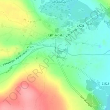
Name: Lillhärdal topographic map, elevation, terrain.
Average elevation: 459 m
Minimum elevation: 426 m
Maximum elevation: 517 m
Make a donation
Gear up for your next adventure:
As an Amazon Associate, this site earns from qualifying purchases at no extra cost to you.
Other topographic maps
Click on a map to view its topography, its elevation and its terrain.
Östersund
Though Östersund is in fact affected by the Gulf Stream, it lacks the high frequency of rain or snow following the currents. This is due to the Scandinavian Mountain Range acting as a natural barrier, receiving most of the precipitation, giving Östersund and the surrounding area a rain deficit. Another issue…
Average elevation: 341 m