Geolocate

Småland topographic map

Click on the map to display elevation.

About this map

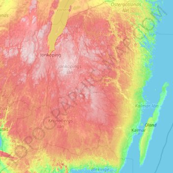
Name: Småland topographic map, elevation, terrain.

Location: Småland, Jönköping County, Region Götaland, Sweden (56.29732 13.07707 58.27188 17.40314)

Average elevation: 122 m

Minimum elevation: -2 m

Maximum elevation: 365 m

Gear up for your next adventure:

🧰Multitool Knife - Compact and versatile tool for outdoor use
Camping Tent - Weather-resistant tents suitable for 2 to 6 people
🛶Kayak Dry Bag - Waterproof storage for kayaking adventures
🕶️Polarized Sunglasses - Reduces glare from snow and water at high elevations
🧢Outdoor Cap - Protective cap for sun and rain during hikes

As an Amazon Associate, this site earns from qualifying purchases at no extra cost to you.