Geolocate

Longview topographic map

Click on the map to display elevation.

About this map

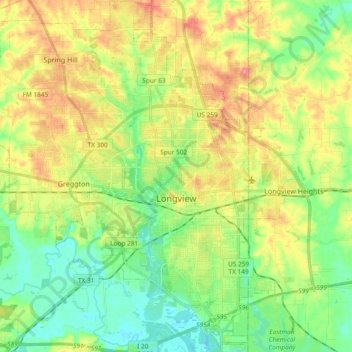
Name: Longview topographic map, elevation, terrain.

Location: Longview, Gregg County, Texas, United States (32.43153 -94.84434 32.58956 -94.66335)

Average elevation: 105 m

Minimum elevation: 68 m

Maximum elevation: 158 m

Other topographic maps

Click on a map to view its topography, its elevation and its terrain.

Liberty City

United States > Texas > Gregg County

Average elevation: 116 m

Gladewater Park

United States > Texas > Gregg County

Average elevation: 98 m

Gear up for your next adventure:

🪑Ultralight Camping Stool - Compact seating for rest stops during long hikes
🧤Rechargeable Heated Gloves - Extreme warmth for Canadian winter expeditions
🔦UV Flashlight - Detect minerals or specific insects in the dark
Bushcraft Tarp - Versatile emergency shelter or gear protection
🥾Approach Boots - Comfortable boots for hiking and climbing approaches

As an Amazon Associate, this site earns from qualifying purchases at no extra cost to you.