
Hailstone Butte topographic map
Interactive map
Click on the map to display elevation.
About this map
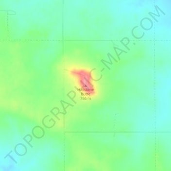
Name: Hailstone Butte topographic map, elevation, terrain.
Average elevation: 684 m
Minimum elevation: 656 m
Maximum elevation: 753 m
Other topographic maps
Click on a map to view its topography, its elevation and its terrain.
Hatton
United States of America > North Dakota > Hatton
Hatton, Traill County, North Dakota, United States of America
Average elevation: 329 m
Devils Lake
United States of America > North Dakota > Devils Lake
Devils Lake, Ramsey County, North Dakota, 58301, United States of America
Average elevation: 443 m
New England
United States of America > North Dakota > New England
New England, Hettinger County, North Dakota, 58647, United States of America
Average elevation: 793 m
Ardoch
United States of America > North Dakota > Ardoch > Ardoch
Ardoch, Walsh County, North Dakota, United States of America
Average elevation: 251 m
Tappen
United States of America > North Dakota > Tappen
Tappen, Kidder County, North Dakota, United States of America
Average elevation: 541 m