
Leh topographic map
Interactive map
Click on the map to display elevation.
About this map
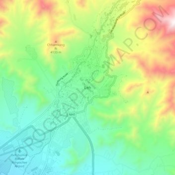
Name: Leh topographic map, elevation, terrain.
Location: Leh, Leh Tehsil, Leh district, Ladakh, India (34.12420 77.54481 34.20420 77.62481)
Average elevation: 3,653 m
Minimum elevation: 3,206 m
Maximum elevation: 4,572 m
Leh (/ˈleɪ/) is the joint capital and largest city of Ladakh, a union territory of India. Leh, located in the Leh district, was also the historical capital of the Kingdom of Ladakh. The seat of the kingdom, Leh Palace, the former residence of the royal family of Ladakh, was built in the same style and about the same time as the Potala Palace in Tibet. Leh is at an altitude of 3,524 m (11,562 ft), and is connected via National Highway 1 to Srinagar in the southwest and to Manali in the south via the Leh-Manali Highway (part of National Highway 3).
Other topographic maps
Click on a map to view its topography, its elevation and its terrain.
Sumdo
India > Ladakh > Leh Tehsil
Sumdo, Leh Tehsil, Leh District, Ladakh, India
Average elevation: 4,663 m
Zanskar
India > Ladakh > Leh Tehsil
Zanskar, Leh Tehsil, Leh district, Ladakh, India
Average elevation: 3,711 m
Indus
India > Ladakh > Leh Tehsil
Indus, Leh Tehsil, Leh District, Ladakh, India
Average elevation: 4,192 m