Geolocate

Kumta topographic map

Click on the map to display elevation.

About this map

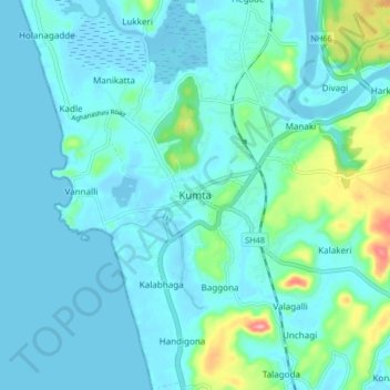
Name: Kumta topographic map, elevation, terrain.

Location: Kumta, Kumata taluk, Uttara Kannada, Karnataka, 581343, India (14.38616 74.37076 14.46616 74.45076)

Average elevation: 18 m

Minimum elevation: -3 m

Maximum elevation: 120 m

Other topographic maps

Click on a map to view its topography, its elevation and its terrain.

Yana's Rocks

India > Karnataka > Kumata taluk > Yana

Average elevation: 413 m

Gear up for your next adventure:

🔦LED Headlamp - Hands-free lighting for early morning starts or late finishes
🧥Fleece Jacket - Warm and lightweight jacket for layering
🧢Hiking Hat - Sun-protective and breathable hats for long treks
🪑Ultralight Camping Stool - Compact seating for rest stops during long hikes
🥾Lightweight Hiking Shoes - Comfortable shoes for day hikes

As an Amazon Associate, this site earns from qualifying purchases at no extra cost to you.