
Tosa Sucha topographic map
Interactive map
Click on the map to display elevation.
About this map
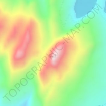
Name: Tosa Sucha topographic map, elevation, terrain.
Location: Tosa Sucha, አርባ ምንጭ / Arba Minch, Gamo Gofa, RNNPS, Éthiopie (5.98840 37.60642 5.98850 37.60652)
Average elevation: 1,376 m
Minimum elevation: 1,158 m
Maximum elevation: 1,637 m
Other topographic maps
Click on a map to view its topography, its elevation and its terrain.
Nechisar National Park Hq
Éthiopie > RNNPS > አርባ ምንጭ / Arba Minch
Nechisar National Park Hq, አርባ ምንጭ / Arba Minch, Gamo Gofa, RNNPS, 40, Éthiopie
Average elevation: 1,216 m
Gughe
Éthiopie > RNNPS > አርባ ምንጭ / Arba Minch
Gughe, አርባ ምንጭ / Arba Minch, Gamo Gofa, RNNPS, Éthiopie
Average elevation: 2,701 m