
Sumatra topographic map
Interactive map
Click on the map to display elevation.
About this map
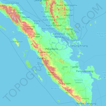
Name: Sumatra topographic map, elevation, terrain.
Location: Sumatra, Indonésie (-5.94301 95.19369 5.65662 106.09736)
Average elevation: 93 m
Minimum elevation: -3 m
Maximum elevation: 3,427 m
Other topographic maps
Click on a map to view its topography, its elevation and its terrain.
Tanah Datar
Indonésie > Riau > Rokan Hulu
Tanah Datar, Kecamatan Kunto Darussalam, Rokan Hulu, Riau, Sumatra, Indonésie
Average elevation: 40 m
Kecamatan Pangkalan Kerinci
Kecamatan Pangkalan Kerinci, Kabupaten Pelalawan, Riau, Indonésie
Average elevation: 14 m
Tanah Datar
Indonésie > Riau > Tanah Datar
Tanah Datar, Kecamatan Rengat Barat, Kabupaten Indragiri Hulu, Riau, Indonésie
Average elevation: 56 m
Pangkalan Kerinci
Indonésie > Riau > Pangkalan Kerinci
Pangkalan Kerinci, Kabupaten Pelalawan, Riau, Indonésie
Average elevation: 9 m