
Make a donation
Gear up for your next adventure:
As an Amazon Associate, this site earns from qualifying purchases at no extra cost to you.
Uthlede topographic map
Click on the map to display elevation.
Make a donation
Gear up for your next adventure:
As an Amazon Associate, this site earns from qualifying purchases at no extra cost to you.
Uthlede
Uthlede liegt zwischen Bremerhaven und Bremen, westlich der Bundesautobahn 27 sowie östlich der Unterweser in Höhe der Flussinsel Harriersand. Die Ortschaft befindet sich im südwestlichen Teil der Einheitsgemeinde Hagen im Bremischen.
Make a donation
Gear up for your next adventure:
As an Amazon Associate, this site earns from qualifying purchases at no extra cost to you.
About this map
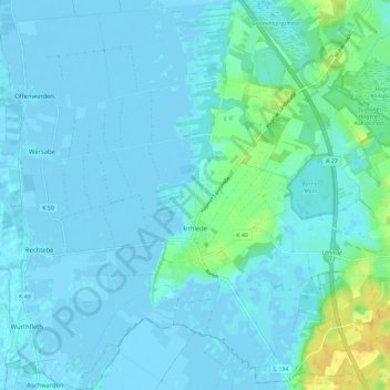
Name: Uthlede topographic map, elevation, terrain.
Average elevation: 3 m
Minimum elevation: -4 m
Maximum elevation: 24 m
Make a donation
Gear up for your next adventure:
As an Amazon Associate, this site earns from qualifying purchases at no extra cost to you.
Other topographic maps
Click on a map to view its topography, its elevation and its terrain.
Dorfhagen
Deutschland > Niedersachsen > Landkreis Cuxhaven > Hagen im Bremischen
Average elevation: 15 m
Wittstedt
Deutschland > Niedersachsen > Landkreis Cuxhaven > Hagen im Bremischen
Average elevation: 5 m
Voßloge
Deutschland > Niedersachsen > Landkreis Cuxhaven > Hagen im Bremischen > Wulsbüttel
Average elevation: 20 m
Harrendorf
Deutschland > Niedersachsen > Landkreis Cuxhaven > Hagen im Bremischen > Bramstedt
Average elevation: 15 m
Make a donation
Gear up for your next adventure:
As an Amazon Associate, this site earns from qualifying purchases at no extra cost to you.
Siedlung Heuberg
Deutschland > Niedersachsen > Landkreis Cuxhaven > Hagen im Bremischen > Wulsbüttel
Average elevation: 13 m