Geolocate

Açude do Cedro topographic map

Click on the map to display elevation.

About this map
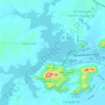
Name: Açude do Cedro topographic map, elevation, terrain.

Location: Açude do Cedro, Quixadá, Região Geográfica Imediata de Quixadá, Região Geográfica Intermediária de Quixadá, Ceará, Região Nordeste, Brasil (-4.99758 -39.08994 -4.95793 -39.05955)

Average elevation: 209 m

Minimum elevation: 187 m

Maximum elevation: 404 m

Other topographic maps

Click on a map to view its topography, its elevation and its terrain.
Dom Maurício

Brasil > Ceará > Quixadá

Average elevation: 555 m

Pedra da Galinha Choca

Brasil > Ceará > Quixadá

Average elevation: 213 m

Juatama

Brasil > Ceará > Quixadá

Average elevation: 227 m

Ouro Preto

Brasil > Ceará > Quixadá > Ouro Preto

Average elevation: 236 m

Pedra do Cruzeiro

Brasil > Ceará > Quixadá

Average elevation: 188 m

Pedra Faladeira

Brasil > Ceará > Quixadá

Average elevation: 214 m

Pedra do Bolo

Brasil > Ceará > Quixadá

Average elevation: 220 m

Serra Estrela

Brasil > Ceará > Quixadá

Average elevation: 334 m

Gear up for your next adventure:

🦌Outdoor Trail Camera - Monitor wildlife activity near your favorite spots
🚲Heavy Duty Bike Lock - Secure your bike at the trailhead or during stops
⛺Camping Essentials - All-in-one gear for a comfortable camping trip
🥾Lightweight Hiking Shoes - Comfortable shoes for day hikes
👟Leg Gaiters - Keep debris, mud, and snow out of your boots

As an Amazon Associate, this site earns from qualifying purchases at no extra cost to you.