Geolocate

Arcadia topographic map

Click on the map to display elevation.

About this map

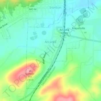
Name: Arcadia topographic map, elevation, terrain.

Location: Arcadia, Iron County, Missouri, United States (37.57560 -90.63716 37.59585 -90.61701)

Average elevation: 300 m

Minimum elevation: 266 m

Maximum elevation: 375 m

Other topographic maps

Click on a map to view its topography, its elevation and its terrain.

Belleview

United States > Missouri > Iron County

Average elevation: 328 m

Russellville

United States > Missouri > Iron County > Arcadia

Average elevation: 299 m

Gear up for your next adventure:

🥾Waterproof Trail Shoes - Shoes designed to handle wet terrain
🧳Compression Sacks - Maximize space in your backpack by shrinking gear
🛌Insulated Sleeping Pad - Critical thermal barrier between you and the cold ground
🧴Outdoor Sunscreen - High SPF protection for high-altitude UV exposure
🧢Sun Hat - Wide-brim hat for sun protection

As an Amazon Associate, this site earns from qualifying purchases at no extra cost to you.