
Make a donation
Gear up for your next adventure:
As an Amazon Associate, this site earns from qualifying purchases at no extra cost to you.
Mohokare Local Municipality topographic map
Click on the map to display elevation.
Make a donation
Gear up for your next adventure:
As an Amazon Associate, this site earns from qualifying purchases at no extra cost to you.
About this map
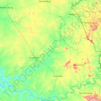
Name: Mohokare Local Municipality topographic map, elevation, terrain.
Average elevation: 1,505 m
Minimum elevation: 1,259 m
Maximum elevation: 2,429 m
Make a donation
Gear up for your next adventure:
As an Amazon Associate, this site earns from qualifying purchases at no extra cost to you.
Other topographic maps
Click on a map to view its topography, its elevation and its terrain.
Zastron
South Africa > Free State > Xhariep District Municipality > Mohokare Local Municipality
Average elevation: 1,719 m
Reddersburg
South Africa > Free State > Xhariep District Municipality > Kopanong Local Municipality
Average elevation: 1,423 m
Rouxville
South Africa > Free State > Xhariep District Municipality > Mohokare Local Municipality
Average elevation: 1,518 m
Smithfield
South Africa > Free State > Xhariep District Municipality > Mohokare Local Municipality
Average elevation: 1,441 m
Make a donation
Gear up for your next adventure:
As an Amazon Associate, this site earns from qualifying purchases at no extra cost to you.
Tierpoort
South Africa > Free State > Xhariep District Municipality > Kopanong Local Municipality
Average elevation: 1,301 m
Fauresmith
South Africa > Free State > Xhariep District Municipality > Kopanong Local Municipality
Average elevation: 1,411 m
Van Stadensrus
South Africa > Free State > Xhariep District Municipality > Naledi Local Municipality
Average elevation: 1,479 m
Jacobsdal
South Africa > Free State > Xhariep District Municipality > Letsemeng Local Municipality
Average elevation: 1,147 m
Make a donation
Gear up for your next adventure:
As an Amazon Associate, this site earns from qualifying purchases at no extra cost to you.
Paardeberg
South Africa > Free State > Xhariep District Municipality > Letsemeng Local Municipality
Average elevation: 1,168 m
Dewetsdorp
South Africa > Free State > Xhariep District Municipality > Naledi Local Municipality
Average elevation: 1,566 m
Gariep Dam
South Africa > Free State > Xhariep District Municipality > Kopanong Local Municipality
Average elevation: 1,266 m
Koffiefontein
South Africa > Free State > Xhariep District Municipality > Letsemeng Local Municipality
Average elevation: 1,203 m
Make a donation
Gear up for your next adventure:
As an Amazon Associate, this site earns from qualifying purchases at no extra cost to you.
Fauresmith
South Africa > Free State > Xhariep District Municipality > Kopanong Local Municipality
Average elevation: 1,411 m
Paardeberg
South Africa > Free State > Xhariep District Municipality > Letsemeng Local Municipality
Average elevation: 1,168 m
Springfontein
South Africa > Free State > Xhariep District Municipality > Kopanong Local Municipality
Average elevation: 1,529 m
Waterkloof
South Africa > Free State > Xhariep District Municipality > Kopanong Local Municipality
Average elevation: 1,343 m
Make a donation
Gear up for your next adventure:
As an Amazon Associate, this site earns from qualifying purchases at no extra cost to you.
Zastron
South Africa > Free State > Xhariep District Municipality > Mohokare Local Municipality
Average elevation: 1,719 m