Geolocate

Chattanooga topographic map

Click on the map to display elevation.

About this map

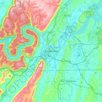
Name: Chattanooga topographic map, elevation, terrain.

Location: Chattanooga, Hamilton County, Tennessee, 818, United States (34.88572 -85.46949 35.20572 -85.14949)

Average elevation: 311 m

Minimum elevation: 189 m

Maximum elevation: 661 m

Other topographic maps

Click on a map to view its topography, its elevation and its terrain.

Gear up for your next adventure:

🥾Hiking Boots - Sturdy boots providing ankle support and traction on rugged trails
🎒Hiking Daypack - Lightweight and durable backpacks for day trips and excursions
🧊Insulated Water Bottle - Keeps drinks cold in summer and prevents freezing in winter
🦟Insect Repellent - Keep mosquitoes and black flies away in wooded areas
🛶Waterproof Dry Bags - Keep electronics and clothes dry during river crossings

As an Amazon Associate, this site earns from qualifying purchases at no extra cost to you.