Geolocate

Auburn topographic map

Click on the map to display elevation.

About this map

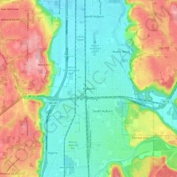
Name: Auburn topographic map, elevation, terrain.

Location: Auburn, King County, Washington, 98071, United States (47.26754 -122.27018 47.34754 -122.19018)

Average elevation: 69 m

Minimum elevation: 9 m

Maximum elevation: 166 m

Gear up for your next adventure:

🧦Crew Hiking Socks - Comfortable socks for long-distance hikes
🧤Rechargeable Heated Gloves - Extreme warmth for Canadian winter expeditions
🧰Emergency Multi-Tool - Compact multi-tool for outdoor survival
🥾Mountain Hiking Boots - High-traction boots for rocky terrain
🥾Trekking Poles - Adjustable trekking poles to reduce knee stress and improve stability

As an Amazon Associate, this site earns from qualifying purchases at no extra cost to you.