
Make a donation
Gear up for your next adventure:
As an Amazon Associate, this site earns from qualifying purchases at no extra cost to you.
Thüste topographic map
Click on the map to display elevation.
Make a donation
Gear up for your next adventure:
As an Amazon Associate, this site earns from qualifying purchases at no extra cost to you.
Thüste
Thüste liegt im äußersten Ostteil vom Naturpark Weserbergland Schaumburg-Hameln in der zum Weser-Leinebergland gerechneten Ith-Hils-Mulde, die 36 km lang und 7 km breit ist und dem Ort sein Gepräge gab. Die den Ort einrahmenden Höhenzüge Ith, Thüster Berg und Duinger Berg sind Jurakämme.
Make a donation
Gear up for your next adventure:
As an Amazon Associate, this site earns from qualifying purchases at no extra cost to you.
About this map
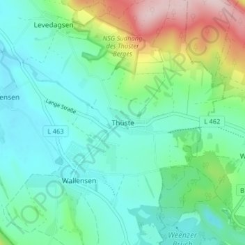
Name: Thüste topographic map, elevation, terrain.
Average elevation: 205 m
Minimum elevation: 135 m
Maximum elevation: 414 m
Make a donation
Gear up for your next adventure:
As an Amazon Associate, this site earns from qualifying purchases at no extra cost to you.