
Make a donation
Gear up for your next adventure:
As an Amazon Associate, this site earns from qualifying purchases at no extra cost to you.
Friedrichsfehn topographic map
Click on the map to display elevation.
Make a donation
Gear up for your next adventure:
As an Amazon Associate, this site earns from qualifying purchases at no extra cost to you.
Friedrichsfehn
1882 wurde die junge Bauerschaft um die Siedlung Mosleshöhe erweitert. 1897–1903 wurden nochmals Kolonate in „Neu Friedrichsfehn“ ausgewiesen (heute: „Roter Steinweg“). Für die Besiedlung von zwei Kolonaten am Hunte-Ems-Kanal (heute: Küstenkanal) konnten niederländische Familien angeworben werden. Durch diese Erweiterungen hat sich die Bevölkerungszahl bis 1905 auf 306 Einwohner fast verdoppelt. 1906 wurde der Artillerie-Schießplatz des Oldenburgischen Feldartillerie-Regimentes Nr. 26 nördlich der Straße nach Edewecht aufgegeben, wodurch nach Ende des Ersten Weltkrieges eine feste Straßenverbindung nach Petersfehn gebaut werden konnte. Nach Fertigstellung der heutigen Brüderstraße Anfang der 1930er Jahre wurden hier Kleinsiedlerstellen ausgewiesen.
Make a donation
Gear up for your next adventure:
As an Amazon Associate, this site earns from qualifying purchases at no extra cost to you.
About this map
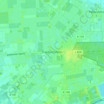
Name: Friedrichsfehn topographic map, elevation, terrain.
Average elevation: 9 m
Minimum elevation: 4 m
Maximum elevation: 16 m
Make a donation
Gear up for your next adventure:
As an Amazon Associate, this site earns from qualifying purchases at no extra cost to you.
Other topographic maps
Click on a map to view its topography, its elevation and its terrain.
26188
Deutschland > Niedersachsen > Landkreis Ammerland > Edewecht > Jeddeloh I
Average elevation: 8 m