Geolocate

Campdevànol topographic map

Click on the map to display elevation.

About this map

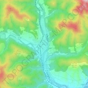
Name: Campdevànol topographic map, elevation, terrain.

Location: Campdevànol, Ripollés, Gerona, Cataluña, 17530, España (42.20306 2.14807 42.24306 2.18807)

Average elevation: 846 m

Minimum elevation: 684 m

Maximum elevation: 1,154 m

Gear up for your next adventure:

Backpacking Tent - Lightweight tent for long-distance hiking trips
🧥Fleece Jacket - Warm and lightweight jacket for layering
🧴Waterproofing Spray - Restore the DWR coating on jackets and tents
🛶Canoe Life Vest - Safety vest for water sports
🧦Crew Hiking Socks - Comfortable socks for long-distance hikes

As an Amazon Associate, this site earns from qualifying purchases at no extra cost to you.