Geolocate

Harlingen topographic map

Click on the map to display elevation.

About this map

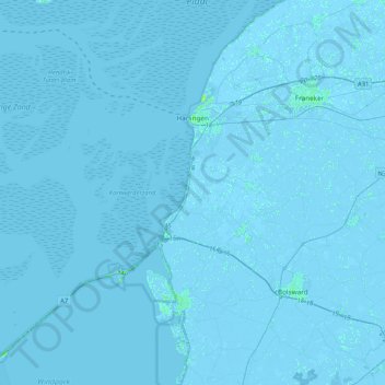
Name: Harlingen topographic map, elevation, terrain.

Location: Harlingen, Frisia, Netherlands (53.00100 5.09578 53.25133 5.49639)

Average elevation: 0 m

Minimum elevation: -5 m

Maximum elevation: 9 m

Other topographic maps

Click on a map to view its topography, its elevation and its terrain.

Oost-Vlieland

Netherlands > Frisia

Average elevation: 2 m

Kooiplaats

Netherlands > Frisia > Buren

Average elevation: 1 m

Loënga

Netherlands > Frisia > Loënga

Average elevation: 0 m

Vierhuizen

Netherlands > Frisia > Allingawier

Average elevation: -2 m

Leeuwarden

Netherlands > Frisia > Leeuwarden

Average elevation: 0 m

Gear up for your next adventure:

🪑Insulated Seat Pad - Protect your seat from cold rocks and wet logs
🔋Lithium AA Batteries - Long-lasting power that performs in extreme cold
🔥Emergency Fire Starter - Reliable ignition source for all weather conditions
🧥Waterproof Hiking Jacket - Protect yourself from rain and wind while hiking
👟Leg Gaiters - Keep debris, mud, and snow out of your boots

As an Amazon Associate, this site earns from qualifying purchases at no extra cost to you.