Geolocate

Sullivan Island topographic map

Click on the map to display elevation.

About this map

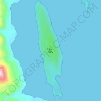
Name: Sullivan Island topographic map, elevation, terrain.

Location: Sullivan Island, Haines Borough, Alaska, United States (58.91608 -135.35413 59.01965 -135.29719)

Average elevation: 67 m

Minimum elevation: -8 m

Maximum elevation: 1,288 m

Other topographic maps

Click on a map to view its topography, its elevation and its terrain.

Excursion Inlet

United States > Alaska > Haines Borough

Average elevation: 148 m

Gear up for your next adventure:

💡LED Headlamp - Hands-free illumination for night hiking and camping
🪑Ultralight Camping Stool - Compact seating for rest stops during long hikes
🥾Durable Hiking Shoes - Long-lasting shoes for frequent hiking
🧤Insulated Winter Gloves - Heavy-duty protection for sub-zero Canadian adventures
🩹Compact First Aid Kit - Pre-packed essentials for common trail injuries

As an Amazon Associate, this site earns from qualifying purchases at no extra cost to you.