Geolocate

North Booval topographic map

Click on the map to display elevation.

About this map

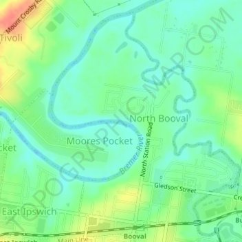
Name: North Booval topographic map, elevation, terrain.

Location: North Booval, Ipswich City, Queensland, Australia (-27.60968 152.77931 -27.58526 152.80309)

Average elevation: 18 m

Minimum elevation: 1 m

Maximum elevation: 51 m

Other topographic maps

Click on a map to view its topography, its elevation and its terrain.

Stanton Cross

Australia > Queensland > Ipswich City

Average elevation: 28 m

Mount Grey

Australia > Queensland > Ipswich City

Average elevation: 231 m

Spring Mountain

Australia > Queensland > Ipswich City

Average elevation: 190 m

White Rock

Australia > Queensland > Ipswich City

Average elevation: 114 m

Gear up for your next adventure:

🧢Sun Protection Cap - Breathable cap to protect from sun exposure
🦟Insect Repellent - Keep mosquitoes and black flies away in wooded areas
👟Leg Gaiters - Keep debris, mud, and snow out of your boots
🍽️Titanium Camping Spork - Ultralight and indestructible eating utensil
🔭Outdoor Binoculars - Lightweight binoculars for birdwatching and hiking

As an Amazon Associate, this site earns from qualifying purchases at no extra cost to you.