Thank you for supporting this site ❤️
Make a donation
Make a donation
Gear up for your next adventure:
As an Amazon Associate, this site earns from qualifying purchases at no extra cost to you.
beleshwar topographic map
Click on the map to display elevation.
Thank you for supporting this site ❤️
Make a donation
Make a donation
Gear up for your next adventure:
As an Amazon Associate, this site earns from qualifying purchases at no extra cost to you.
About this map
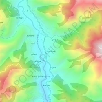
Name: beleshwar topographic map, elevation, terrain.
Location: beleshwar, Ghansali, Tehri Garhwal, Uttarakhand, 249181, India (30.44392 78.61784 30.48392 78.65784)
Average elevation: 1,225 m
Minimum elevation: 860 m
Maximum elevation: 1,852 m
Thank you for supporting this site ❤️
Make a donation
Make a donation
Gear up for your next adventure:
As an Amazon Associate, this site earns from qualifying purchases at no extra cost to you.
