
Thank you for supporting this site ❤️
Make a donation
Make a donation
Gear up for your next adventure:
As an Amazon Associate, this site earns from qualifying purchases at no extra cost to you.
Moggast topographic map
Click on the map to display elevation.
Thank you for supporting this site ❤️
Make a donation
Make a donation
Gear up for your next adventure:
As an Amazon Associate, this site earns from qualifying purchases at no extra cost to you.
Moggast
Das Pfarrdorf liegt im südlichen Randbereich der Wiesentalb. Es befindet sich etwa fünfeinhalb Kilometer ostsüdöstlich des Ortszentrums von Ebermannstadt und liegt auf einer Höhe von 493 m ü. NHN.
Thank you for supporting this site ❤️
Make a donation
Make a donation
Gear up for your next adventure:
As an Amazon Associate, this site earns from qualifying purchases at no extra cost to you.
About this map
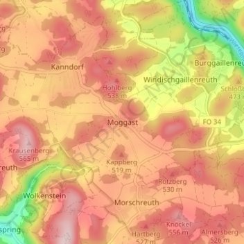
Name: Moggast topographic map, elevation, terrain.
Average elevation: 473 m
Minimum elevation: 308 m
Maximum elevation: 569 m
Thank you for supporting this site ❤️
Make a donation
Make a donation
Gear up for your next adventure:
As an Amazon Associate, this site earns from qualifying purchases at no extra cost to you.