Geolocate

Gabiano topographic map

Click on the map to display elevation.

About this map

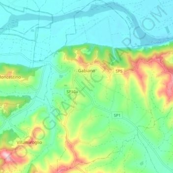
Name: Gabiano topographic map, elevation, terrain.

Location: Gabiano, Alessandria, Piemont, Italy (45.12522 8.17170 45.17833 8.24350)

Average elevation: 196 m

Minimum elevation: 130 m

Maximum elevation: 372 m

Gear up for your next adventure:

🧥Thermal Layer - Insulating layer for cold outdoor conditions
🧶550 Survival Paracord - Versatile utility cord for emergency repairs and rigging
🧥Ultralight Puffy Jacket - Maximum warmth that packs down to the size of an orange
🩹Moleskin Blister Pads - Direct protection for painful foot pressure points
🔪Outdoor Multitool - Versatile tool for repairs and food prep in the wild

As an Amazon Associate, this site earns from qualifying purchases at no extra cost to you.