
Make a donation
Gear up for your next adventure:
As an Amazon Associate, this site earns from qualifying purchases at no extra cost to you.
Oostmalle topographic map
Click on the map to display elevation.
Make a donation
Gear up for your next adventure:
As an Amazon Associate, this site earns from qualifying purchases at no extra cost to you.
Oostmalle
Oostmalle heeft een oppervlakte van 28,27 km² en telde in 2013 7034 inwoners. Oostmalle ligt in de Voorkempen op zandige bodem. De hoogte bedraagt 12-28 meter. Het belangrijkste natuurgebied ligt ten zuiden van de kom, namelijk 's Herenbos, Heihuizen en Zalfen. In het noorden vindt men het Klokkeven, gevormd door kleiputten. In het zuiden vindt men ook het Zalfens Gebroekt.
Make a donation
Gear up for your next adventure:
As an Amazon Associate, this site earns from qualifying purchases at no extra cost to you.
About this map
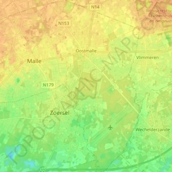
Name: Oostmalle topographic map, elevation, terrain.
Location: Oostmalle, Malle, Antwerpen, 2390, België (51.24248 4.70185 51.32684 4.77665)
Average elevation: 20 m
Minimum elevation: 4 m
Maximum elevation: 30 m
Make a donation
Gear up for your next adventure:
As an Amazon Associate, this site earns from qualifying purchases at no extra cost to you.
Other topographic maps
Click on a map to view its topography, its elevation and its terrain.