Geolocate

Borkum topographic map

Click on the map to display elevation.

About this map

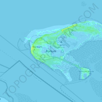
Name: Borkum topographic map, elevation, terrain.

Location: Borkum, Landkreis Leer, Lower Saxony, 26757, Germany (53.55501 6.64324 53.61748 6.81992)

Average elevation: 0 m

Minimum elevation: -12 m

Maximum elevation: 16 m

Gear up for your next adventure:

🧭Orienteering Kit - Tools for map reading and navigation in the wild
🧥Waterproof Hiking Jacket - Protect yourself from rain and wind while hiking
🎒Hiking Daypack - Lightweight and durable backpacks for day trips and excursions
🎒Fully Waterproof Backpack - Total protection for photography gear and electronics
🥘Camping Cookware Set - Compact nesting pots and pans for trail cooking

As an Amazon Associate, this site earns from qualifying purchases at no extra cost to you.