Geolocate

Culaba topographic map

Click on the map to display elevation.

About this map

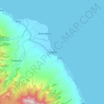
Name: Culaba topographic map, elevation, terrain.

Location: Culaba, Biliran, Eastern Visayas, 6547, Philippines (11.61560 124.50062 11.69560 124.58062)

Average elevation: 124 m

Minimum elevation: -1 m

Maximum elevation: 1,021 m

Other topographic maps

Click on a map to view its topography, its elevation and its terrain.

Maripipi

Philippines > Biliran

Average elevation: 52 m

Biliran

Philippines > Biliran

Average elevation: 170 m

Anas River

Philippines > Biliran > Larrazabal

Average elevation: 200 m

Sambawan Islands

Philippines > Biliran > Maripipi

Average elevation: 0 m

Biliran

Philippines > Biliran

Average elevation: 170 m

Gear up for your next adventure:

💡Portable Camping Lamp - Rechargeable lamp for campsite lighting
🥾Hiking Boots - Sturdy boots providing ankle support and traction on rugged trails
🥾Light Hiking Boots - Lightweight and comfortable boots for day hikes
💧Hydration Pack - Hands-free hydration system for long hikes
🛶Canoe Life Vest - Safety vest for water sports

As an Amazon Associate, this site earns from qualifying purchases at no extra cost to you.