
Make a donation
Gear up for your next adventure:
As an Amazon Associate, this site earns from qualifying purchases at no extra cost to you.
Meldert topographic map
Click on the map to display elevation.
Make a donation
Gear up for your next adventure:
As an Amazon Associate, this site earns from qualifying purchases at no extra cost to you.
Meldert
Meldert ligt in Zandlemig Vlaanderen op een hoogte van 17-72,5 meter. Van belang is de groeve aan de Putstraat waarin van het 3e kwart van de 12e eeuw tot het derde kwart van de 18e eeuw de zogenaamde Meldertse zandsteen werd gewonnen. De belangrijkste waterloop is de Molenbeek, die in westelijke richting stroomt.
Make a donation
Gear up for your next adventure:
As an Amazon Associate, this site earns from qualifying purchases at no extra cost to you.
About this map
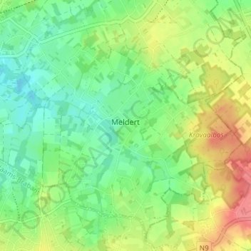
Name: Meldert topographic map, elevation, terrain.
Location: Meldert, Aalst, Oost-Vlaanderen, Vlaanderen, België (50.91697 4.10103 50.95299 4.16245)
Average elevation: 41 m
Minimum elevation: 14 m
Maximum elevation: 81 m
Make a donation
Gear up for your next adventure:
As an Amazon Associate, this site earns from qualifying purchases at no extra cost to you.
Other topographic maps
Click on a map to view its topography, its elevation and its terrain.