
Vargas topographic map
Interactive map
Click on the map to display elevation.
About this map
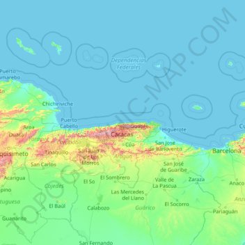
Name: Vargas topographic map, elevation, terrain.
Location: Vargas, Venezuela (8.05054 -69.45824 13.17054 -64.33824)
Average elevation: 116 m
Minimum elevation: -1 m
Maximum elevation: 2,590 m
Other topographic maps
Click on a map to view its topography, its elevation and its terrain.
Cerro Grande
Venezuela > Vargas > Parroquia Caraballeda
Cerro Grande, Parroquia Caraballeda, Municipio Vargas, Vargas, Región Capital, 1164, Venezuela
Average elevation: 337 m