Geolocate

Capucnasan topographic map

Click on the map to display elevation.

About this map

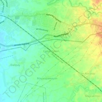
Name: Capucnasan topographic map, elevation, terrain.

Location: Capucnasan, Camarines Sur, Bicol Region, 4400, Philippines (13.58728 123.19876 13.62728 123.23876)

Average elevation: 18 m

Minimum elevation: 2 m

Maximum elevation: 39 m

Other topographic maps

Click on a map to view its topography, its elevation and its terrain.

Del Gallego

Philippines > Camarines Sur

Average elevation: 91 m

Sagñay

Philippines > Camarines Sur

Average elevation: 163 m

Caramoan

Philippines > Camarines Sur

Average elevation: 42 m

Gear up for your next adventure:

🧥Softshell Hiking Jacket - The perfect balance of wind protection and breathability
🥾Lightweight Hiking Shoes - Comfortable shoes for day hikes
🔦UV Flashlight - Detect minerals or specific insects in the dark
Camping Coffee Maker - Brew fresh coffee anywhere on the topographic map
🥽Outdoor Goggles - Protective eyewear for outdoor activities

As an Amazon Associate, this site earns from qualifying purchases at no extra cost to you.