
Fairfield topographic map
Click on the map to display elevation.
About this map
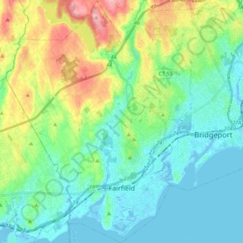
Name: Fairfield topographic map, elevation, terrain.
Average elevation: 37 m
Minimum elevation: -8 m
Maximum elevation: 138 m
Other topographic maps
Click on a map to view its topography, its elevation and its terrain.
Nichols
United States > Connecticut > Greater Bridgeport Planning Region > Trumbull
Average elevation: 59 m
Oronoque Hills North
United States > Connecticut > Greater Bridgeport Planning Region > Stratford > Oronoque
Average elevation: 47 m
Mill Plain
United States > Connecticut > Greater Bridgeport Planning Region > Fairfield > Southport
Average elevation: 16 m
Oronoque
United States > Connecticut > Greater Bridgeport Planning Region > Stratford
Average elevation: 37 m
Southport
United States > Connecticut > Greater Bridgeport Planning Region > Fairfield
Average elevation: 11 m
Stepney
United States > Connecticut > Greater Bridgeport Planning Region > Monroe
Average elevation: 123 m
Greenfield Hill
United States > Connecticut > Greater Bridgeport Planning Region > Fairfield
Average elevation: 53 m
Stevenson
United States > Connecticut > Greater Bridgeport Planning Region > Monroe
Average elevation: 106 m
Melville Village
United States > Connecticut > Greater Bridgeport Planning Region > Fairfield > Stratfield
Average elevation: 39 m
Long Hill
United States > Connecticut > Greater Bridgeport Planning Region > Trumbull
Average elevation: 117 m
Powells Hill
United States > Connecticut > Greater Bridgeport Planning Region > Easton
Average elevation: 87 m
Long Hill
United States > Connecticut > Greater Bridgeport Planning Region > Trumbull
Average elevation: 117 m
Barn Hill
United States > Connecticut > Greater Bridgeport Planning Region > Monroe
Average elevation: 146 m
Stratfield
United States > Connecticut > Greater Bridgeport Planning Region > Fairfield
Average elevation: 53 m
Lordship Beach
United States > Connecticut > Greater Bridgeport Planning Region > Stratford > Lordship
Average elevation: 1 m