
Salaverry topographic map
Interactive map
Click on the map to display elevation.
About this map
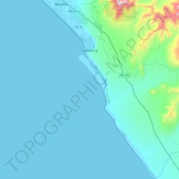
Name: Salaverry topographic map, elevation, terrain.
Location: Salaverry, Provincia de Trujillo, La Libertad, Perú (-8.37177 -78.99936 -8.16667 -78.80245)
Average elevation: 102 m
Minimum elevation: -2 m
Maximum elevation: 1,114 m
Abarca una superficie de 295,88 km² y se encuentra ubicado a 14 km al sur de Trujillo a los 8°13´12” de latitud sur y a 78°14´12” de longitud oeste. Tiene una altitud de 3 msnm.