Geolocate

Mansuè topographic map

Click on the map to display elevation.

About this map

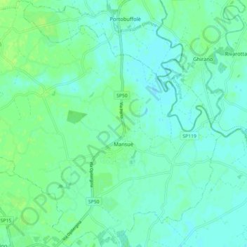
Name: Mansuè topographic map, elevation, terrain.

Location: Mansuè, Province of Treviso, Veneto, 31040, Italy (45.79647 12.48542 45.85850 12.57320)

Average elevation: 11 m

Minimum elevation: 6 m

Maximum elevation: 18 m

Gear up for your next adventure:

🧼Biodegradable Camp Soap - Environmentally friendly cleaning for gear and body
🧰Emergency Multi-Tool - Compact multi-tool for outdoor survival
🚑Survival Whistle - Signal for help across long distances in mountains
🥾Trail Hiking Shoes - Durable shoes designed for rugged trails
🥤Collapsible Travel Cup - Saves space and weight in your mess kit

As an Amazon Associate, this site earns from qualifying purchases at no extra cost to you.