
San Borja topographic map
Interactive map
Click on the map to display elevation.
About this map
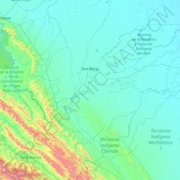
Name: San Borja topographic map, elevation, terrain.
Average elevation: 338 m
Minimum elevation: 150 m
Maximum elevation: 2,225 m
San Borja está situada a una altitud de 197 metros sobre el nivel del mar. En cuanto a distancia, San Borja se encuentra a 152 km de Rurrenabaque, a 234 km de Trinidad y a 365 km de La Paz. La capital del municipio forma parte de la Ruta Nacional 3 de Bolivia.
Other topographic maps
Click on a map to view its topography, its elevation and its terrain.