Geolocate

Solopaca topographic map

Click on the map to display elevation.

About this map

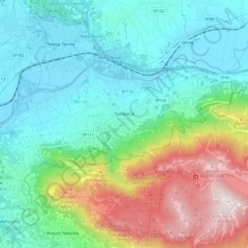
Name: Solopaca topographic map, elevation, terrain.

Location: Solopaca, Benevento, Campania, 82036, Italy (41.16359 14.49485 41.21876 14.59868)

Average elevation: 416 m

Minimum elevation: 37 m

Maximum elevation: 1,375 m

Other topographic maps

Click on a map to view its topography, its elevation and its terrain.

Fonte Coppo La Vigna

Italy > Campania > Benevento > Pietraroja

Average elevation: 1,146 m

Bagnoli

Italy > Campania > Benevento > Sant'Agata de' Goti

Average elevation: 203 m

San Lazzaro

Italy > Campania > Benevento > Sant'Agata de' Goti

Average elevation: 321 m

Colle dell'Impiso

Italy > Campania > Benevento > Colle Sannita

Average elevation: 799 m

Ferrarisi

Italy > Campania > Benevento > Casalduni

Average elevation: 251 m

Gear up for your next adventure:

👟Leg Gaiters - Keep debris, mud, and snow out of your boots
💧Reusable Water Bottle - Durable water bottles for hydration on trails
🥾Approach Boots - Comfortable boots for hiking and climbing approaches
🛁Quick-Dry Microfiber Towel - Space-saving towel that dries rapidly on the move
🚲Heavy Duty Bike Lock - Secure your bike at the trailhead or during stops

As an Amazon Associate, this site earns from qualifying purchases at no extra cost to you.