Geolocate

Cordon topographic map

Click on the map to display elevation.

About this map

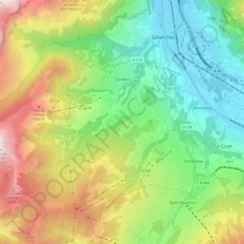
Name: Cordon topographic map, elevation, terrain.

Location: Cordon, Bonneville, Upper Savoy, Auvergne-Rhône-Alpes, Metropolitan France, 74700, France (45.88107 6.50945 45.93460 6.62589)

Average elevation: 1,179 m

Minimum elevation: 534 m

Maximum elevation: 2,247 m

Other topographic maps

Click on a map to view its topography, its elevation and its terrain.

Gear up for your next adventure:

🍽️Titanium Camping Spork - Ultralight and indestructible eating utensil
🔦LED Flashlight - Powerful and long-lasting flashlight for camping and emergencies
💡LED Camping Lantern - Illuminate your campsite with long-lasting lanterns
❄️Traction Ice Cleats - Slip-on spikes for icy trails and winter hiking
🔭Compact Binoculars - Lightweight optics for scouting trails and wildlife

As an Amazon Associate, this site earns from qualifying purchases at no extra cost to you.