
District de Bo Trach topographic map
Interactive map
Click on the map to display elevation.
About this map
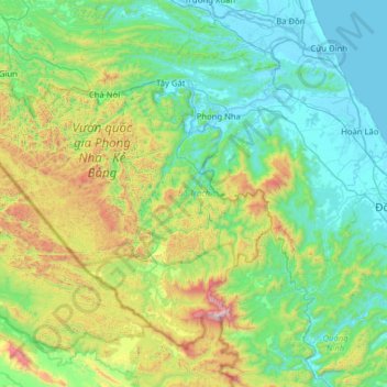
Name: District de Bo Trach topographic map, elevation, terrain.
Location: District de Bo Trach, Province de Quảng Bình, Viêt Nam (17.24376 105.96824 17.72938 106.60022)
Average elevation: 356 m
Minimum elevation: -3 m
Maximum elevation: 1,596 m
Other topographic maps
Click on a map to view its topography, its elevation and its terrain.
Kiến Giang
Viêt Nam > Province de Quảng Bình > Kiến Giang
Kiến Giang, District de Lệ Thủy, Province de Quảng Bình, Viêt Nam
Average elevation: 3 m