Geolocate

Manasa topographic map

Click on the map to display elevation.

About this map

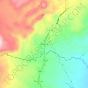
Name: Manasa topographic map, elevation, terrain.

Location: Manasa, Lucban, Quezon, Calabarzon, 4328, Philippines (14.04980 121.55223 14.08980 121.59223)

Average elevation: 404 m

Minimum elevation: 220 m

Maximum elevation: 631 m

Other topographic maps

Click on a map to view its topography, its elevation and its terrain.

Camatian River

Philippines > Quezon > Lucban

Average elevation: 549 m

Botocan River

Philippines > Quezon > Lucban > Kalyaat

Average elevation: 389 m

Gear up for your next adventure:

🐕Hiking Dog Pack - Let your canine companion carry their own water and food
🧦Thermal Socks - Warm socks for winter hiking or camping
🥾Durable Hiking Shoes - Long-lasting shoes for frequent hiking
🧥Packable Rain Jacket - Breathable waterproof layer for unpredictable weather
🔦UV Flashlight - Detect minerals or specific insects in the dark

As an Amazon Associate, this site earns from qualifying purchases at no extra cost to you.