Geolocate

Paracale topographic map

Click on the map to display elevation.

About this map

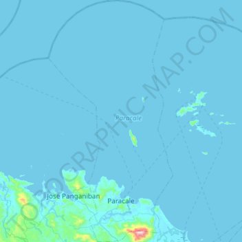
Name: Paracale topographic map, elevation, terrain.

Location: Paracale, Camarines Norte, Bicol Region, 4605, Philippines (14.19918 122.64061 14.67190 122.89276)

Average elevation: 11 m

Minimum elevation: -2 m

Maximum elevation: 743 m

Other topographic maps

Click on a map to view its topography, its elevation and its terrain.

Labo

Philippines > Camarines Norte

Average elevation: 30 m

Moreno

Philippines > Camarines Norte > Daet

Average elevation: 7 m

Gear up for your next adventure:

🧦Hiking Socks - Moisture-wicking and comfortable socks for long hikes
🔦LED Flashlight - Powerful and long-lasting flashlight for camping and emergencies
🧥Thermal Layer - Insulating layer for cold outdoor conditions
Family Camping Tent - Spacious tent suitable for family camping trips
🐕Hiking Dog Pack - Let your canine companion carry their own water and food

As an Amazon Associate, this site earns from qualifying purchases at no extra cost to you.