Geolocate

Kaliasem topographic map

Click on the map to display elevation.

About this map

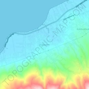
Name: Kaliasem topographic map, elevation, terrain.

Location: Kaliasem, Buleleng, Bali, 00362, Indonesia (-8.19099 115.00482 -8.15099 115.04482)

Average elevation: 68 m

Minimum elevation: 0 m

Maximum elevation: 354 m

Other topographic maps

Click on a map to view its topography, its elevation and its terrain.

Tejakula

Indonesia > Bali > Buleleng

Average elevation: 500 m

Pengastulan

Indonesia > Bali > Buleleng

Average elevation: 7 m

Gerokgak

Indonesia > Bali > Buleleng

Average elevation: 197 m

Lake Tamblingan

Indonesia > Bali > Buleleng

Average elevation: 1,280 m

Gear up for your next adventure:

💧Collapsible Water Bottle - Space-saving water bottle for outdoor activities
🔦LED Headtorch - Bright and durable light for night activities
🧢Beanie Hat - Keep your head warm in cold weather
Camping Groundsheet - Protect your tent from moisture and dirt
Backpacking Tent - Lightweight tent for long-distance hiking trips

As an Amazon Associate, this site earns from qualifying purchases at no extra cost to you.