Geolocate

Hatley topographic map

Click on the map to display elevation.

About this map

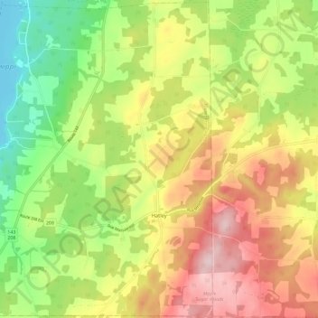
Name: Hatley topographic map, elevation, terrain.

Location: Hatley, Memphrémagog, Estrie, Quebec, Canada (45.16007 -72.03253 45.24040 -71.91729)

Average elevation: 294 m

Minimum elevation: 158 m

Maximum elevation: 445 m

Memphrémagog trails, hiking, mountain biking, running and outdoor activities

Other topographic maps

Click on a map to view its topography, its elevation and its terrain.

Mont Boisjoli

Canada > Quebec > Memphrémagog > Hatley (Canton)

Average elevation: 267 m

Club-Hermitage

Canada > Quebec > Memphrémagog > Magog

Average elevation: 224 m

Mansonville

Canada > Quebec > Memphrémagog > Potton

Average elevation: 211 m

Georgeville

Canada > Quebec > Memphrémagog > Stanstead (Canton)

Average elevation: 237 m

Mont Orford

Canada > Quebec > Memphrémagog > Orford

Average elevation: 559 m

Mont Owl's Head

Canada > Quebec > Memphrémagog > Potton

Average elevation: 370 m

Vale Perkins

Canada > Quebec > Memphrémagog > Potton

Average elevation: 287 m

Gear up for your next adventure:

🧊Portable Cooler - Keep food and drinks cold during outdoor adventures
🚲Bike Repair Kit - Essential tools for on-trail mechanical issues
🎒Hiking Daypack - Lightweight and durable backpacks for day trips and excursions
🔭Compact Monocular - One-handed bird watching and trail spotting
💡LED Headlamp - Hands-free illumination for night hiking and camping

As an Amazon Associate, this site earns from qualifying purchases at no extra cost to you.