
Make a donation
Gear up for your next adventure:
As an Amazon Associate, this site earns from qualifying purchases at no extra cost to you.
Mount Venamo topographic map
Click on the map to display elevation.
Make a donation
Gear up for your next adventure:
As an Amazon Associate, this site earns from qualifying purchases at no extra cost to you.
Mount Venamo
A mountain in Guyana named Waukauyengtipu is often mistakenly synonymized with Mount Venamo, yet they are separate plateaus and each should be recognized by their respective, separate names. Most of the information about the true location and elevation of Cerro Venamo is taken from the results of Julian A. Steyermark's and G. C. K. Dunsterville's botanical exploration of the mountain in Venezuela in 1963 and 1964. Due to the assumptions regarding the geography of the massif having been made with only the instrumentation available at that time, some information, especially its area and elevation, has proven to be inaccurate when compared to modern satellite data. Waukauyengtipu is situated approximately 27 km southeast of Cerro Venamo.
Make a donation
Gear up for your next adventure:
As an Amazon Associate, this site earns from qualifying purchases at no extra cost to you.
About this map
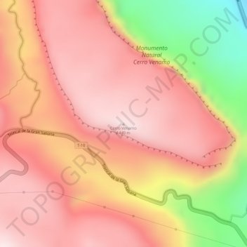
Name: Mount Venamo topographic map, elevation, terrain.
Average elevation: 1,293 m
Minimum elevation: 971 m
Maximum elevation: 1,437 m
Make a donation
Gear up for your next adventure:
As an Amazon Associate, this site earns from qualifying purchases at no extra cost to you.