Geolocate

Iola topographic map

Click on the map to display elevation.

About this map

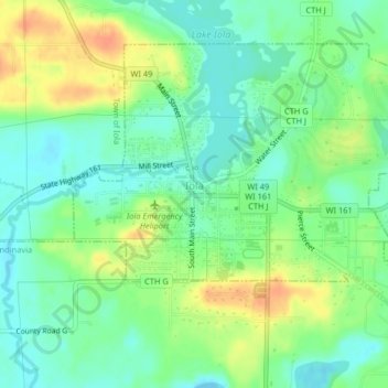
Name: Iola topographic map, elevation, terrain.

Location: Iola, Waupaca County, Wisconsin, United States (44.49612 -89.14340 44.51864 -89.10274)

Average elevation: 299 m

Minimum elevation: 283 m

Maximum elevation: 322 m

Other topographic maps

Click on a map to view its topography, its elevation and its terrain.

King

United States > Wisconsin > Waupaca County

Average elevation: 278 m

Readfield

United States > Wisconsin > Waupaca County

Average elevation: 252 m

Holman Lake

United States > Wisconsin > Waupaca County

Average elevation: 282 m

Gear up for your next adventure:

🧭GPS Outdoor Watch - Smart watch for navigation and fitness tracking in nature
🧤Thermal Hiking Gloves - Grip-enhanced gloves for cold-weather altitude trekking
🔦UV Flashlight - Detect minerals or specific insects in the dark
🥾Mountain Hiking Shoes - Shoes with superior grip for mountainous terrain
🔭Compact Monocular - One-handed bird watching and trail spotting

As an Amazon Associate, this site earns from qualifying purchases at no extra cost to you.