
Make a donation
Gear up for your next adventure:
As an Amazon Associate, this site earns from qualifying purchases at no extra cost to you.
Chiaramonte Gulfi topographic map
Click on the map to display elevation.
Make a donation
Gear up for your next adventure:
As an Amazon Associate, this site earns from qualifying purchases at no extra cost to you.
Chiaramonte Gulfi
Chiaramonte Gulfi is located on a hill-top 15 kilometres (9 mi) north of Ragusa at an altitude of 668 metres (2,192 ft) above sea level. The highest point is on Monte Arcibessi at 907 metres (2,976 ft). Its hamlets (frazioni) are the villages of Piano dell'Acqua, Roccazzo and Sperlinga.
Make a donation
Gear up for your next adventure:
As an Amazon Associate, this site earns from qualifying purchases at no extra cost to you.
About this map
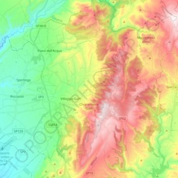
Name: Chiaramonte Gulfi topographic map, elevation, terrain.
Location: Chiaramonte Gulfi, Ragusa, Sicily, 97012, Italy (36.98552 14.54323 37.10659 14.73564)
Average elevation: 498 m
Minimum elevation: 188 m
Maximum elevation: 910 m
Make a donation
Gear up for your next adventure:
As an Amazon Associate, this site earns from qualifying purchases at no extra cost to you.