Geolocate

Shire Of Manjimup topographic map

Click on the map to display elevation.

About this map

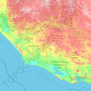
Name: Shire Of Manjimup topographic map, elevation, terrain.

Location: Shire Of Manjimup, Western Australia, Australia (-35.12594 115.63419 -34.12685 116.85647)

Average elevation: 115 m

Minimum elevation: -2 m

Maximum elevation: 350 m

Other topographic maps

Click on a map to view its topography, its elevation and its terrain.

Watervalley Park

Australia > Western Australia

Average elevation: 29 m

Moorehead

Australia > Western Australia

Average elevation: 197 m

Kings Park

Australia > Western Australia > Perth

Average elevation: 31 m

Swan River

Australia > Western Australia

Average elevation: 113 m

Augusta

Australia > Western Australia > Augusta

Average elevation: 31 m

Honeymoon Bay

Australia > Western Australia

Average elevation: 7 m

Cooke Creek

Australia > Western Australia > Onslow

Average elevation: 2 m

Minah Point Yard

Australia > Western Australia

Average elevation: 220 m

Ardath

Australia > Western Australia > Ardath

Average elevation: 285 m

Joondalup

Australia > Western Australia

Average elevation: 33 m

Gear up for your next adventure:

🧥Insulated Jacket - Keep warm in cold outdoor conditions
👟Leg Gaiters - Keep debris, mud, and snow out of your boots
🥾Light Trekking Boots - Supportive boots for multi-day treks
Camping Groundsheet - Protect your tent from moisture and dirt
🔋Solar Power Bank - Keep your GPS and devices charged during long outdoor trips

As an Amazon Associate, this site earns from qualifying purchases at no extra cost to you.