Geolocate

Boti topographic map

Click on the map to display elevation.

About this map

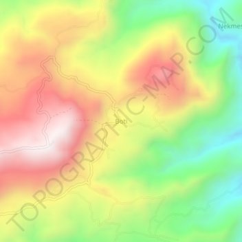
Name: Boti topographic map, elevation, terrain.

Location: Boti, Timor Tengah Selatan, East Nusa Tenggara, Indonesia (-9.97189 124.51856 -9.93189 124.55856)

Average elevation: 602 m

Minimum elevation: 170 m

Maximum elevation: 1,035 m

Other topographic maps

Click on a map to view its topography, its elevation and its terrain.

Gear up for your next adventure:

👖Convertible Hiking Pants - Zip-off legs to adapt to changing weather conditions
Lightweight Camping Tent - Portable shelter optimized for Canadian backcountry camping
🧥Waterproof Hiking Jacket - Protect yourself from rain and wind while hiking
💧Filtered Water Bottle - Safe drinking water on the go
🔋Solar Power Bank - Keep your GPS and devices charged during long outdoor trips

As an Amazon Associate, this site earns from qualifying purchases at no extra cost to you.