Geolocate

Mindoro topographic map

Click on the map to display elevation.

About this map

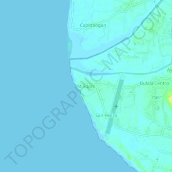
Name: Mindoro topographic map, elevation, terrain.

Location: Mindoro, Vigan, Ilocos Sur, Ilocos Region, 2700, Philippines (17.53910 120.32880 17.57910 120.36880)

Average elevation: 2 m

Minimum elevation: 0 m

Maximum elevation: 24 m

Other topographic maps

Click on a map to view its topography, its elevation and its terrain.

Plaza Burgos

Philippines > Ilocos Sur > Vigan > Barangay III

Average elevation: 10 m

Govantes River

Philippines > Ilocos Sur > Vigan > Capangpangan

Average elevation: 10 m

Gear up for your next adventure:

🧥Softshell Jacket - Windproof and breathable jacket for hiking
🥾Trekking Poles - Adjustable trekking poles to reduce knee stress and improve stability
🧥Insulated Jacket - Keep warm in cold outdoor conditions
🚲MTB Frame Bag - Carry tools and maps directly on your bicycle frame
🧦Thermal Socks - Warm socks for winter hiking or camping

As an Amazon Associate, this site earns from qualifying purchases at no extra cost to you.