
Make a donation
Gear up for your next adventure:
As an Amazon Associate, this site earns from qualifying purchases at no extra cost to you.
Hofstade topographic map
Click on the map to display elevation.
Make a donation
Gear up for your next adventure:
As an Amazon Associate, this site earns from qualifying purchases at no extra cost to you.
About this map
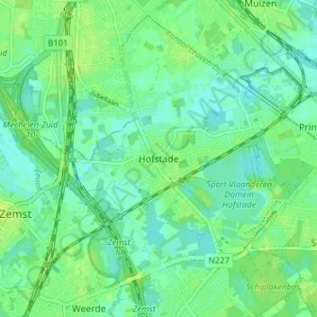
Name: Hofstade topographic map, elevation, terrain.
Average elevation: 8 m
Minimum elevation: 2 m
Maximum elevation: 14 m
Make a donation
Gear up for your next adventure:
As an Amazon Associate, this site earns from qualifying purchases at no extra cost to you.
Other topographic maps
Click on a map to view its topography, its elevation and its terrain.
Eppegem
België > Vlaams-Brabant > Halle-Vilvoorde > Zemst
Eppegem ligt aan de Zenne en de Afleiding van de Zenne. De bodem is zandlemig en de hoogte bedraagt ongeveer 10 meter. Belangrijke natuurgebieden zijn.
Average elevation: 11 m
Zennevallei met het Kasteeldomein van Relegem
België > Vlaams-Brabant > Halle-Vilvoorde > Zemst
Average elevation: 8 m
Make a donation
Gear up for your next adventure:
As an Amazon Associate, this site earns from qualifying purchases at no extra cost to you.