Make a donation
Gear up for your next adventure:
As an Amazon Associate, this site earns from qualifying purchases at no extra cost to you.
Lorch topographic map
Click on the map to display elevation.
Make a donation
Gear up for your next adventure:
As an Amazon Associate, this site earns from qualifying purchases at no extra cost to you.
About this map
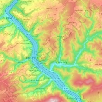
Name: Lorch topographic map, elevation, terrain.
Location: Lorch, Rheingau-Taunus-Kreis, Hesse, 65391, Germany (50.00650 7.77247 50.12857 7.92543)
Average elevation: 315 m
Minimum elevation: 72 m
Maximum elevation: 609 m
Make a donation
Gear up for your next adventure:
As an Amazon Associate, this site earns from qualifying purchases at no extra cost to you.
Other topographic maps
Click on a map to view its topography, its elevation and its terrain.
Wehener Wand und Rentmauer Wiesbaden
Germany > Hesse > Rheingau-Taunus-Kreis > Wiesbaden
Average elevation: 377 m
Make a donation
Gear up for your next adventure:
As an Amazon Associate, this site earns from qualifying purchases at no extra cost to you.
Teufelskadrich bei Lorch
Germany > Hesse > Rheingau-Taunus-Kreis > Rüdesheim am Rhein > Assmannshausen
Average elevation: 253 m
